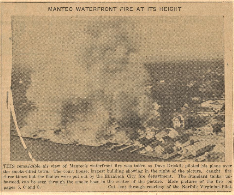
The Manteo fire broke out in the early hours of that September morning and destroyed 21 buildings in just three hours. Since the town had limited supplies to fight the fire, trucks from neighboring communities had to be called in to help contain the flames and one even came down from Norfolk, Virginia to offer aid. Miraculously, not a single person was injured amidst the chaos.
Sometimes, it’s easy to feel like the problems of today are unique to our time and place, but this latest batch of the Carteret County News-Times (1960-1963) demonstrates that people have been working through similar problems for at least 50 years. One issue, from March 16, 1962, somehow touches on big storms flooding the area (and the difficulty of insuring coastal property), U.S. House elections, and redistricting—almost as if it were printed in 2022.
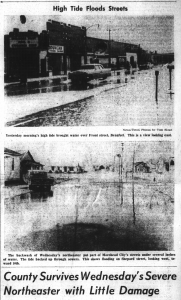
Luckily, no one died in the nor’easter that hit Morehead City and the rest of the coast in March 1962, but the storm did cause quite a bit of damage. A paper from the preceding week (March 2, 1962) pictures flooding along some of the commercial streets and describes buildings that were not up to code to withstand the storm. One commissioner reported that an insurance firm in New York abstained from insuring the area because of the building code problems. A week later, a headline reads (perhaps unsurprisingly): “Red Cross Says Best Way to Help Dare Is Give to Local Red Cross.”
Another front page story describes a bid for the 3rd Congressional District by Morehead City resident S.A. Chalk Jr. Chalk Jr. ran against incumbent David Henderson in the Democratic primary (though in a much different Democratic party than we think of today). He accused Henderson of voting for “policies that are bound to cause even further trouble,” saying, “He claims he’s conservative, but his voting records do not bear this out.” Chalk Jr. still lost the primary, apparently, as Henderson went on to represent the district until 1977.
Aside from the familiar arguments of House elections, the article also mentions that Harnett County was added to the district in 1960. And while the headlines haven’t changed much over the last 50 years, the list of counties included in the 3rd District certainly has. In 1962, the district included 10 counties: Carteret, Craven, Duplin, Harnett, Jones, Onslow, Pamlico, Pender, Sampson, and Wayne. In 2023, the district will expand and morph to contain parts of 15 counties: Beaufort, Camden, Carteret, Craven, Currituck, Dare, Duplin, Hyde, Jones, Lenoir, Onslow, Pamlico, Pitt (partly), Sampson, and Wayne (partly). For visual thinkers, an interactive map of NC’s congressional districts can be found here.
DigitalNC is happy to offer two new yearbooks from the Wayne County Public Library. The yearbooks are from Eureka High School, located in Eureka, NC, which had a population of about 200 people at the 2010 census. These yearbooks offer a nice look into the life of a small community school during the 1950’s. Although it is described as a high school, both yearbooks feature 1st-12th grade classes. Yearbooks like these could be excellent resources for genealogy research, especially about this small community.
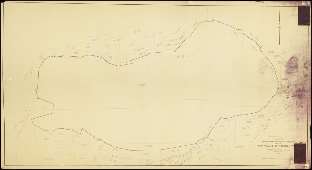
While we are no strangers to digitizing large objects here at DigitalNC, our newest partner, the Hyde County Historical and Genealogical Society, gave us quite the scanning challenge with their 1934 Mattamuskeet Lake Migratory Bird Refuge Grant Map! Measuring in at 6ft 4in by 3ft 9in, the map was over a foot longer than our largest scanning table. Since it was impossible for us to scan the whole map in one shot, we had to utilize our Phase One camera and its removable table top to scan the map in parts using a horizontal scrolling type technique.
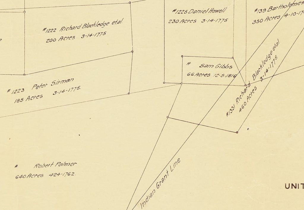
A portion of the map was set up on the table top with small weights carefully applied to hold the map in place and edges down while library carts and people supported the parts of the map off the table. Once a portion was scanned, the weights would be removed, the map shifted for the next portion (with overlap), and weights reapplied. This process was repeated over 30 times. Afterwards, the scanned images were pieced together to create an impressive full digital image of the map which shows the boundary of the lake and parcels of land along with individual parcel owner names, dates the land was acquired, and parcel acreage. A more detailed version of the map can be viewed here on DigitalNC.
Lake Mattamuskeet is recognized as North Carolina’s largest natural freshwater lake—stretching 18 miles long, seven miles wide, and averaging only two to three feet deep. While the lake may be shallow, its history is certainly not. The following paragraphs provide some information about the lake’s ancient and more recent past, but detailing its full history is beyond the scope of this blog post. If you are interested in learning more, please visit the resources that are linked at the end of this post.
At least 800 years before England’s 1584 expedition arrived at Roanoke Island, the coastal region of the state was occupied by several small Native American tribes, including the Algonquian-speaking Machapunga (also known as the Mattamuskeet or Marimiskeet American Indians). The Machapunga were a small tribe of the Algonquin language living in the Pungo River area who migrated south from the Algonquin peoples of the Powhatan Confederacy.
At that time, the Mattamuskeet were known as skillful watermen who made their boats and nets of size interlocks for herring, drum, shad, netting needles, and floats. In addition to their work on the water, they hunted; trapped; gathered berries, nuts, and fruit; and farmed. They grew plants such as corn, beans, pumpkins, goosefoot, sunflowers, knotweed, and squash. The women of the Machapunga are specifically noted as being fierce warriors. Today, the genealogical descendants from the original historic Mattamuskeet Indians of Hyde County, along with the original historic Roanoke-Hatteras (Croatan) Indians of Dare County comprise the Alogonquian Indians of North Carolina.
In 1934, the Mattamuskeet Lake Migratory Bird Refuge Grant Map was created—showing parcel boundaries along with providing the name of the parcel’s owner, the acreage, and the date it was acquired. Some names present on the map, such as Collins, Barber, Chance, Clayton, and Bryant, can trace their American Indian heritage back to the Mattamuskeet. The same year the map was published, the lake was acquired by the United States Government and the Mattamuskeet National Wildlife Refuge was established. This was likely a result of Roosevelt’s New Deal policies that helped provide jobs and relief to citizens during the Great Depression. Today, the Mattamuskeet National Wildlife Refuge (which includes the lake and surrounding area) remains federally protected and supports “large numbers of wintering waterfowl, as well as a variety of breeding songbirds, mammals such as black bear and bobcat, and other wildlife.”
To learn more about the Hyde County Historical and Genealogical Society, please visit their website linked here.
To view more maps of North Carolina on DigitalNC, click the following link.
Thanks to our partner, Dare County Library, new issues of The Coastland Times are now available on our website. These issues range from 1962 to 1966. Popular topics in these issues include environmental protection of the coast, the building of bridges and roads, and the area’s popular theater scene.
In 1955, Betty MacDonald published a humorous memoir titled Onions in the Stew. The book recounts MacDonald’s move to Washington State with her two preteen daughters as a divorced working mother and their adaption to living in Washington State from 1942 to 1954. After meeting and marrying her second husband, the family settles for living on the fringe of the Western wilderness on Vashon Island in Puget Sound after being unable to find a home in Seattle or its suburbs. City folks at heart, the MacDonald family hilariously deals with adapting to life in the country.
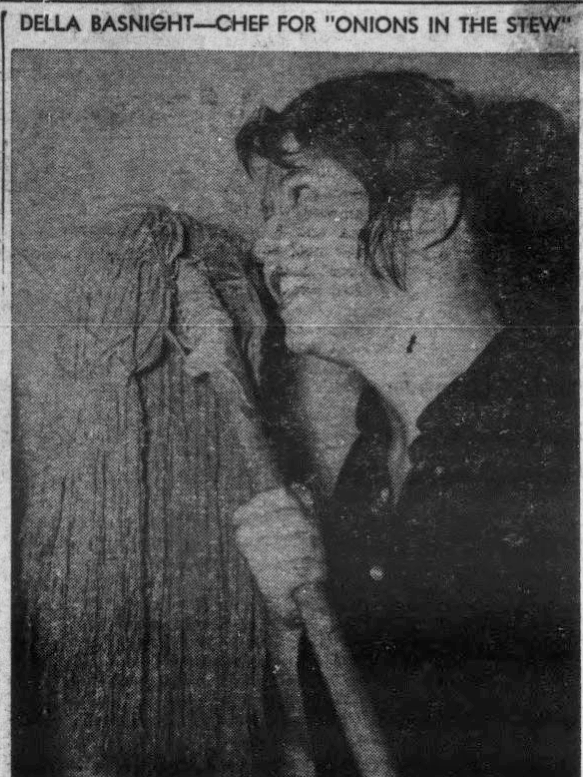
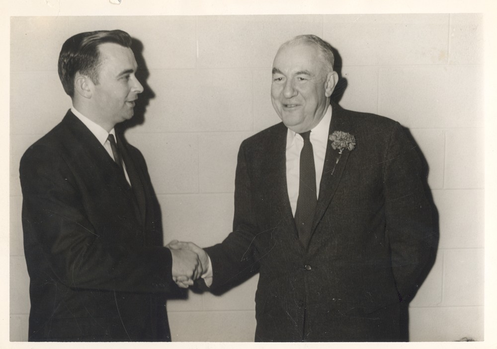
In April 1962, the Manteo High School Senior Class performed an adaption of Onions in the Stew to a packed house. The class was under the direction of Mrs. Ida Edwards and Miss Mabel Jean Basnight. Credit for the play’s success was given to Miss Della Basnight (pictured left) for her skill in acting as the mother of two.
Ervin’s column stands out today for how it differs from contemporary political propaganda. For one thing, it was published in local papers, which tend to focus on local and regional news. For example, one column from the September 13, 1963 issue runs next to a news brief headlined, “Sea Hags Will Meet,” referring to a local fishing club.
Another notable quality of Ervin’s column is that it is… relatively boring. Rather than employing inflammatory language or focusing on hot-button issues, Ervin tends to give technical overviews of the mechanisms of the Senate. In the column published on October 18, 1963, the Senator references a “controversial Foreign Aid Bill” and then writes, “Present prospects are that there may be no action taken by the Senate as a whole on the tax bill. There is a growing feeling that action on the tax measure should be postponed until after the President’s Budget message to Congress the first of the year.” Even though it is presumably written for a general audience, Ervin often chooses to use technical language and focus on bureaucratic details rather than argue for a bigger picture or stance.
You can read more of Ervin’s unexpected (by contemporary standards) columns and more of The Coastland Times in this latest batch of issues. You can also browse all of our digital newspapers in our North Carolina Newspapers collection. To see more materials from the Dare County Library, visit their partner page and their website.
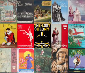
The Lost Colony, written by Paul Green, has been a cultural touchstone of the Outer Banks since the late thirties; several of our digitized newspapers from the area make references to it (you can read one blog post about The Nags Tale and another about The Dare County Times). Some sources say it is the longest running symphonic drama in the country.
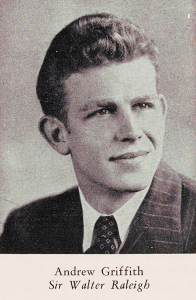
Of the many notable figures who have participated in the annual play season, one of the most recognizable and beloved is actor Andy Griffith. Griffith was born in Mount Airy, N.C. and acted in The Lost Colony for seven seasons (1947-1953), starring as Sir Walter Raleigh for the later five. He may have been the subject of one of the souvenir program’s best covers (1952), which is reused as a dedication to him in 2013 just after he died. In fact, Griffith is buried on Roanoke Island.
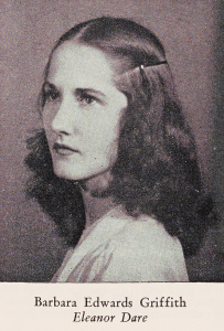
What makes these souvenir programs even more interesting is that Griffith’s first wife, Barbara Edwards, was also in a starring role of The Lost Colony for several years. She played Eleanor Dare, mother of Virginia Dare (famously said to be the first English child born in the Americas). Edwards Griffith was the first native North Carolinian to play the female lead and was “the most successful actress to portray the difficult role” thanks to her “excellent voice and splendid acting ability,” according to the 1953 program.
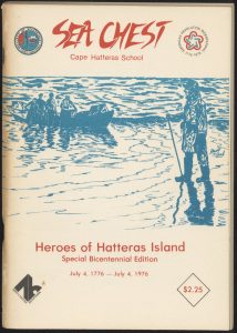
A new batch of 23 publications of the school magazine from Cape Hatteras School (now Cape Hatteras Secondary School) dating back from 1973 to 2000 has been digitized and made available on DigitalNC, courtesy of our partner, the Dare County Library.
The Sea Chest is a magazine written by students at Cape Hatteras School . While learning about journalism and everyday skills, the students use the publication as a way to document and preserve North Carolina coast culture. They would do this through their articles, interviews with community members, and photographs.
To learn more about the Dare County Library, you can find more information by visiting their partner page or taking a look at their website.
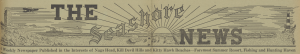
Another newspaper title from the eastern part of our state has been added to our digital collections thanks to our partner, the Outer Banks History Center. These issues of The Seashore News were published for the Nags Head, Kill Devil Hills, and Kitty Hawk beach communities in 1939.
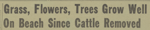
One article from the June 8, 1939 issue describes a different beach scene than many of us are used to today.
“Dare County is being reborn,” it begins. “Where only a year or two ago the eye was greeted with vast stretches of bare sand and course beach grass, upon which herds of stunted cattle eked out a miserable existance [sic], today is springing to life lush vegetation, acres of wild flowers and trees and flowering shrubs of a hundred varieties.”
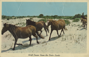
The article goes on to describe how the “Stock Law” passed in 1937 by the State Legislature helped eliminate the cattle, wild horses, and “scuttling flocks of mangy sheep” from the beaches. The author also claims that the beaches were a “veritable paradise of verdure” when colonists first arrived and that it was due to the livestock that the beaches became “a territory that was fast taking on the arid aspects of a desert.”
Whether the introduction of vegetation to the area would be considered “conservation” by today’s standards isn’t totally clear, though the NC Wildlife Resources Commission doesn’t exactly describe costal habitats as a “‘delicate garden abounding with all kinds of odiferous flowers.'”
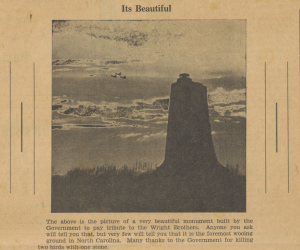
The Wright Monument, or what the caption writer calls, “the foremost wooing ground in North Carolina.”
The reviewer notes, first and foremost, the incredibly large cast of the production, commenting, “There are 186 people in the company of ‘The Lost Colony,’ and when Sir Walter’s colony passed through an inlet that cut the banks between Nags Head and the Wright Memorial, there were only 108 people in the expedition come to lay the foundation of an empire.”
Despite the unusually large cast (which doesn’t include the crew members, the reviewer points out), the production seemed to be a hit among the residents of the island.
This blog is maintained by the staff of the North Carolina Digital Heritage Center and features the latest news and highlights from the collections at DigitalNC, an online library of primary sources from organizations across North Carolina.
![Map title and associated information. United States Department of Agriculture Bureau of Biologial Survey. Jay. N. Darling. Chief.
Mattamuskeet Lake Migratory Bird Refuge Grant Map.
New Holland Corporation Tr[?].
(3)
Hyde County. North Carolina.
R.C.F. Surveyor.
1934.
Scale 1:15,840
[Bar for scale]](https://www.digitalnc.org/wp-content/uploads/2023/11/default-1-1-1024x623.jpg)
 Of the many notable figures who have participated in the annual play season, one of the most recognizable and beloved is actor