North Carolina’s Blue Ridge Parkway
Document Presets
To download, choose the "Save as PDF" option when asked to choose a printer.
Primary Source Set
North Carolina’s Blue Ridge Parkway
Spanning 469 miles between Virginia and North Carolina, the Blue Ridge Parkway has long been a favorite destination of tourists. While the Parkway is loved by many today, its history is marked by a series of disputes and controversies over route planning, eminent domain, and other land issues. This primary source set uses photographs, newspaper articles, and a map to explain the conflicts and agreements leading to the creation of the Blue Ridge Parkway, and to demonstrate the effects of the Parkway on western North Carolina.
Time Period
1933-1962
Selected Sources
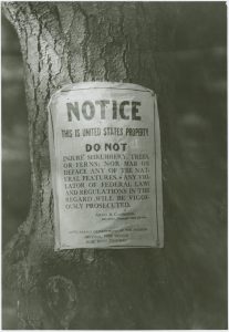
Blue Ridge Parkway Land
Blue Ridge Parkway, N.C. (Ashe County), 1970
The Blue Ridge Parkway is owned by the United States government through the National Park Service. Areas of land that surround the road itself, including plant life, are also United States property. As the Parkway was designed to be scenic and natural, the government made the road non-commercial (businesses and advertisements are prohibited). This photograph shows a sign posted on a tree that reminds visitors of its federal ownership and warns them to not “…mar or deface any of the [Parkway’s] natural features.”
Contributed to DigitalNC by Ashe County Public Library, Appalachian Regional Library
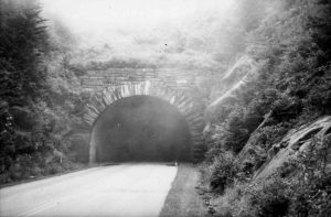
Devil's Courthouse Tunnel
Blue Ridge Parkway, N.C. (Transylvania County), 1970
This photograph depicts the Devil’s Courthouse Tunnel, one of many tunnels located along the route of the Blue Ridge Parkway. The Parkway contains 26 tunnels, 25 of which are in North Carolina, including the Devil’s Courthouse. Tunnels were carved out with the help of drills and dynamite. Labor on tunnels and other parts of the Parkway was mostly performed by private contractors.
Contributed to DigitalNC by Transylvania County Library
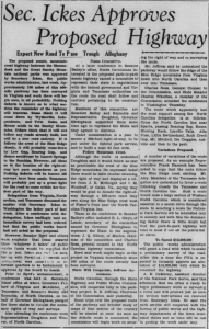
"Sec. Ickes Approves Proposed Highway"
Sparta, N.C. (Alleghany County), 1933
As part of his New Deal programs meant to strengthen the country’s economy, President Franklin D. Roosevelt created the Public Works Administration (PWA) in 1933 to fund projects like the Blue Ridge Parkway. PWA projects were intended to combat the Great Depression by creating jobs and constructing valuable public works for the country. This article from The Alleghany Times discusses the initial approval and funding of the Parkway project by Secretary Harold Ickes, head of the PWA.
Contributed to DigitalNC by Alleghany County Public Library, State Archives of North Carolina
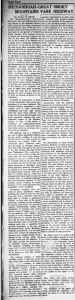
"Shenandoah-Great Smoky Mountains National Parkway"
West Jefferson, N.C. (Ashe County), 2025
Stanley W. Abbott, a landscape architect, was a key figure in designing the Blue Ridge Parkway. In this article from The Skyland Post, he discusses his plans for the Parkway. Through planting programs and careful route planning, Abbott states, the road will retain the beauty of the natural scenery and bring tourism to western North Carolina. However, he also acknowledges that obtaining land for the parkway is a “stubborn and time-taking problem.”
Contributed to DigitalNC by Ashe County Public Library, University of North Carolina at Chapel Hill
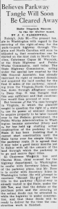
"Believes Parkway Tangle Will Soon Be Cleared Away"
Henderson, N.C. (Vance County), 1935
This article from The Henderson Daily Dispatch discusses legal issues preventing the construction of the Blue Ridge Parkway. To begin building the Parkway, the government had to obtain a right-of-way, which would allow the Parkway’s creators to have ownership of the land. In turn, this would let them start constructing the road and landscaping the surrounding areas. North Carolina purchased most of the land for the parkway using the power of eminent domain, meaning that they forced landowners to sell their properties to the state.
Contributed to DigitalNC by University of North Carolina at Chapel Hill
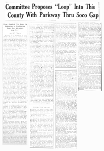
"Committee Proposes 'Loop' Into This County With Parkway Thru Soco Gap"
Waynesville, N.C. (Haywood County), 1934
The Blue Ridge Parkway project was started, in part, as a way to connect the Shenandoah National Park in Virginia to the Great Smoky Mountains National Park in North Carolina and Tennessee. However, major conflict was caused by two conflicting route proposals submitted by North Carolina and Tennessee. While Tennessee suggested a route that traveled into parts of both states, North Carolina’s proposal positioned the route only in North Carolina, skipping Tennessee completely. This article from The Waynesville Mountaineer reports on a hearing in Washington D.C. that would help decide which route would receive approval. According to the article, the speakers for the North Carolina proposal emphasized scenery and tourism in their arguments for their preferred route.
Contributed to DigitalNC by Haywood County Public Library, University of North Carolina at Chapel Hill, State Archives of North Carolina
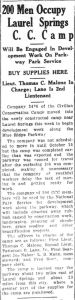
"200 Men Occupy Laurel Springs C.C.Camp"
North Wilkesboro, N.C. (Wilkes County), 1938
The Public Works Administration (PWA) was formed via FDR’s New Deal to create jobs for Americans who struggled to find employment during the Great Depression. The Civilian Conservation Corps (CCC), another New Deal program, often worked in conjunction with PWA projects. Young men enlisted in the CCC to work on natural resource-related projects across the country. According to this 1938 article from The Journal-Patriot, members of a CCC camp in Laurel Springs planned to complete development work on the Parkway, a PWA project. Their tasks included “…clearing away rubbish caused by construction work, landscaping, planting of shrubbery, grass seeding and other beautification projects.”
Contributed to DigitalNC by Wilkes County Public Library, University of North Carolina at Chapel Hill
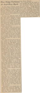
"Blue Ridge Parkway At Half-Way Mark"
Blowing Rock, N.C. (Watauga County), 1941
The Blue Ridge Parkway is the most visited site in the National Park system, drawing the largest number of visitors every year since the 1940s. This article from The Blowing Rocket discusses some of the Parkway’s attractions to tourists, including its plants, flowers, scenery, and its nearby towns, cities, and resorts. Although increased tourism from the Parkway did aid western North Carolina’s economy, wealthy white business owners who owned pre-existing tourist attractions benefited the most from the influx of Parkway visitors.
Contributed to DigitalNC by University of North Carolina at Chapel Hill, Watauga County Historical Society, Blowing Rock Community Library, Watauga County Public Library, Appalachian State University, Blowing Rock Historical Society
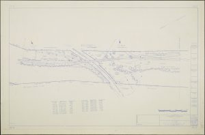
Blue Ridge Parkway, Southeast Region Sheet 4
Blue Ridge Parkway, N.C., 1967
Route planning was not the only integral part of constructing the Blue Ridge Parkway. As depicted in this map and others, the design of the surrounding landscape was another important element of the Parkway. Sightlines through the trees were considered in planning, as were the addition of plants, trees, and shrubbery.
Contributed to DigitalNC by Western Carolina University
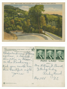
Yonahlossee Trail on Blue Ridge Parkway, Western North Carolina
Blowing Rock, N.C. (Watauga County, Caldwell County), 1953
This postcard depicts the Yonahlossee Trail, formerly a part of the Blue Ridge Parkway before the final part of the Parkway, Linn Cove Viaduct, was finished in 1987. The back of the postcard includes a handwritten message that celebrates the “beautiful sight” of the Parkway’s blooming rhododendrons, flame azaleas, and laurel.
Contributed to DigitalNC by Braswell Memorial Library (Rocky Mount, N.C.)
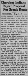
"Cherokee Indians Reject Proposal For Scenic Route"
Shelby, N.C. (Cleveland County), 1935
In 1935, Parkway planners and the North Carolina State Highway Commission proposed a new link to the Blue Ridge Parkway. The link would run through the Qualla Boundary, the territory of the Eastern Band of Cherokee Indians. Although the Cherokee had wished for a regular state highway through the Qualla Boundary to improve travel, the proposed route for the Parkway would travel Soco Valley, an area of heavily populated farmland. Additionally, the proposal suggested a thousand foot right-of-way, which would take up huge portions of the Cherokee’s lands in the valley. To protect their land, the Cherokee tribal council voted against the proposal in June of 1935. This article from The Cleveland Star reports that the council rejected another route proposal several months later, in December of 1935.
Contributed to DigitalNC by Cleveland County Memorial Library, University of North Carolina at Chapel Hill
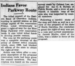
"Indians Favor Parkway Route"
West Jefferson, N.C. (Ashe County), 1940
In 1938, Parkway planners offered the Eastern Band of Cherokee a new route, one that would not encroach on important Soco Valley farmland. Planners also assured the Cherokee that they would construct the much-needed state highway through the Qualla Boundary if the tribe agreed to the offer. Although former tribal council members remained opposed to this Parkway route, the council voted to approve it in 1940. This Skyland Post article reports on the council’s approval of the new route.
Contributed to DigitalNC by University of North Carolina at Chapel Hill, Ashe County Public Library
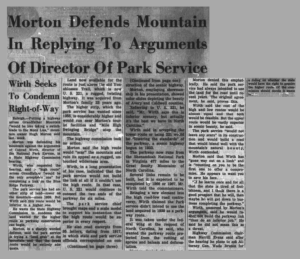
"Morton Defends Mountain In Replying To Arguments Of Director Of Park Service"
Boone, N.C. (Watauga County), 1962
Although tourists had regularly visited the Blue Ridge Parkway since the 1930s, it was not until 1987 that the Parkway was finished. Problems with completion had begun in the 1950s, when conflict arose between the National Park Service, North Carolina’s State Highway Commission, and Hugh Morton, the private owner and developer of Grandfather Mountain. The Park Service was responsible for planning the Parkway route on Grandfather Mountain. This route, or “missing link,” would finally complete the Blue Ridge Parkway.
Morton, who owned tourist attractions on the mountain, protested the Park Service’s proposed route. By citing environmental and conservation concerns, he garnered enough support from government officials to prevent the construction of the planned route. This article from The Watauga Democrat reports that Morton said putting the Parkway on Grandfather Mountain “would be like taking a switchblade to the Mona Lisa.” Eventually, the Park Service reached a compromise with Morton on a different route for Grandfather Mountain in 1968. The final 7 miles of the Blue Ridge Parkway were built there between 1968 and 1987.
Contributed to DigitalNC by Watauga County Public Library
Background
The Blue Ridge Parkway is a road that spans 469 miles along the Blue Ridge Mountains in Virginia and North Carolina. The Parkway has been one of the most-visited sites in the National Park Service system since the 1940s, drawing crowds of visitors who wish to view the mountain scenery and enjoy nearby towns and tourist attractions. Although the Blue Ridge Parkway was formed to provide employment for job-seekers, improve local economies through increased tourist traffic, and connect two national parks, the road’s history shows that conflict played a key role in preventing these goals. Disagreements over route planning, eminent domain, and other land issues were a significant hurdle in building the Parkway.
The project to build the Blue Ridge Parkway was first put into action in 1933 with funding from the Public Works Administration (PWA), a New Deal agency established to create jobs for the unemployed by funding large public works projects. After funds were received and planning of the Parkway began, arguments arose over how the road would be routed. The Parkway was meant to connect two national parks together: the Shenandoah National Park in Virginia and the Great Smoky Mountains National Park in North Carolina and Tennessee. Two conflicting proposals for the route were submitted by North Carolina and Tennessee officials, leading to a long battle over which state’s preferred route would receive approval from the federal government. The federal government held hearings on the issue until the North Carolina route won approval in 1934. North Carolina lobbyists–many of them businessmen in the tourist industry–helped support their state’s proposal. As sections of the Parkway were completed, already-established tourist areas of western North Carolina, like Asheville, Blowing Rock, and Little Switzerland, saw significant economic benefits from increased tourism.
Routing proposals were not the only source of conflict for the Parkway. After the North Carolina route plan had been approved, the state government had to take ownership of the lands that the route would pass through. As Parkway planners wished to retain the beauty of the surrounding scenery, the government also had to establish ownership over the land beside where the road would be built. This meant that Parkway planners would be in control of areas of land, sometimes up to a thousand feet, adjacent to the Parkway itself.
North Carolina used the power of eminent domain to take control over lands for the Blue Ridge Parkway. With this power, North Carolina forcibly bought land from thousands of landowners living along the future Parkway route. Although Parkway advocates often claimed the road would bring economic gain to the region through tourist visits, many of these rural landowners received no great profit from Parkway tourism. Eminent domain caused them to lose their lands and homes, and they often had little choice in refusing to sell their property for the Parkway. Other land and routing issues arose with the Eastern Band of Cherokee Indians. While Cherokee land was not threatened by eminent domain, it was a subject of intense disagreement between the Cherokee tribal council, the National Park Service, and the North Carolina State Highway Commission for years. Parkway planners initially offered the Cherokee council a route that would cut through valuable farmland in Soco Valley and encroach on many people’s lands and homes. By 1940, however, the Cherokee accepted a new route proposal that bypassed Soco Valley.
Even after past issues had been resolved, more problems emerged and prevented the completion of the Blue Ridge Parkway. World War II put a temporary stop to construction work on the Parkway from 1943 to the end of the war. In the 1950s and 1960s, the owner of popular tourist attractions on Grandfather Mountain blocked Parkway planners from building the final “missing link” of the Parkway. Construction did not begin on the last seven miles of the Blue Ridge Parkway until 1968, when a compromise had finally been reached between the National Park Service and the Grandfather Mountain owner. It was not until 1987, when work on those seven miles had finished, that the Blue Ridge Parkway was completed.
Discussion Questions
Consider this article on Secretary Ickes from The Alleghany Times and this C.C.C. camp article from The Journal-Patriot. What were some of the reasons that the Blue Ridge Parkway was created? How does the Parkway connect to New Deal programs created by President Franklin D. Roosevelt?
Take a look at this article from The Henderson Daily Dispatch, making sure to focus on how the article depicts the “parkway tangle.” How does the article describe the eminent domain issue? Whose perspective in the conflict does it consider and uplift? Whose perspective does it neglect?
This Waynesville Mountaineer article reports on a hearing about Blue Ridge Parkway route proposals submitted by Tennessee and North Carolina. According to the article, six speakers argued that the North Carolina route—not the Tennessee route—was the better option for the Parkway.
- Consider the six people who spoke for the North Carolina route at the hearing, making sure to notice their careers. What perspectives are most prominent here?
- What arguments did the speakers make to convince attendees at the hearing that the North Carolina route was the better option? What aspects of North Carolina did they highlight?
Conflict, controversy, and disagreement played a significant part in the history of the Blue Ridge Parkway.
- What kinds of conflicts are a part of the Parkway’s history? What themes or topics do you notice in disagreements about the Parkway?
- How did conflict prevent and/or change the planning and construction of the Blue Ridge Parkway?
In what ways did the construction of the Blue Ridge Parkway change western North Carolina? Consider geography and nature, the economy, and local communities.
These materials were compiled by Isabella Walker. Updated April 2025.
https://www.digitalnc.org/primary-source-sets/north-carolinas-blue-ridge-parkway/
This document was prepared for print on September 4, 2025.