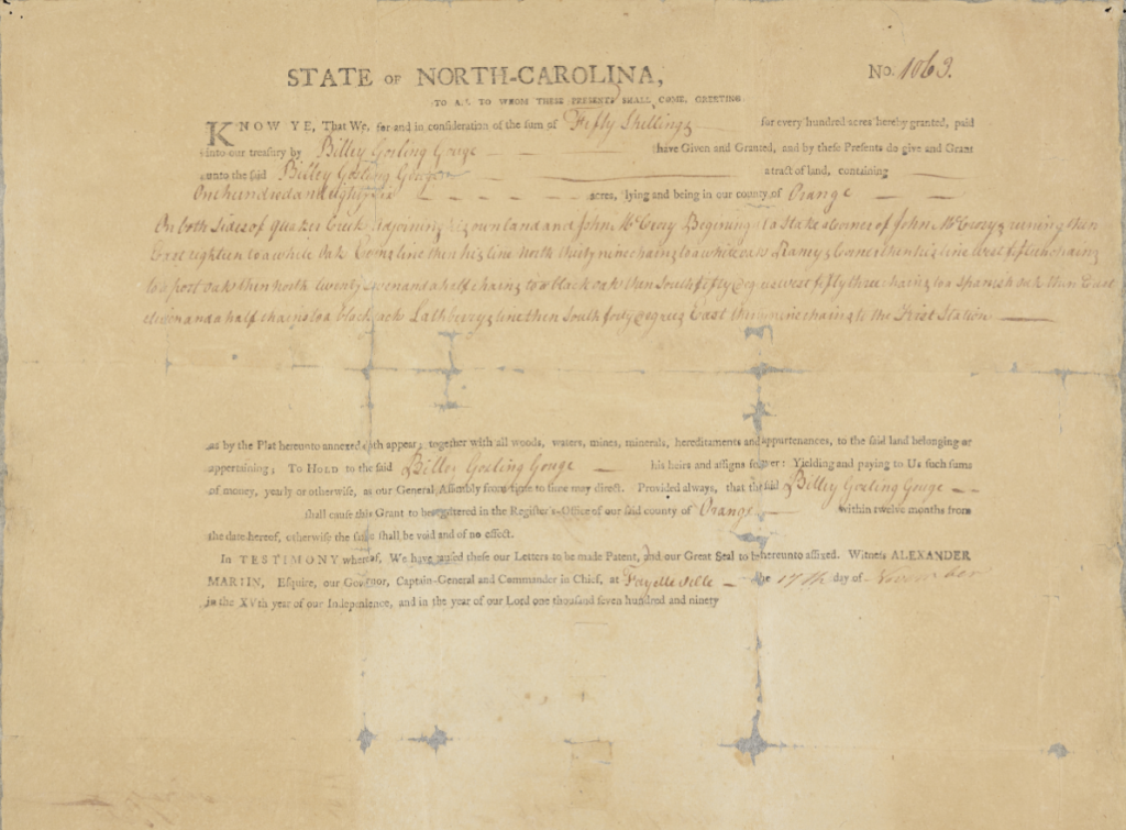
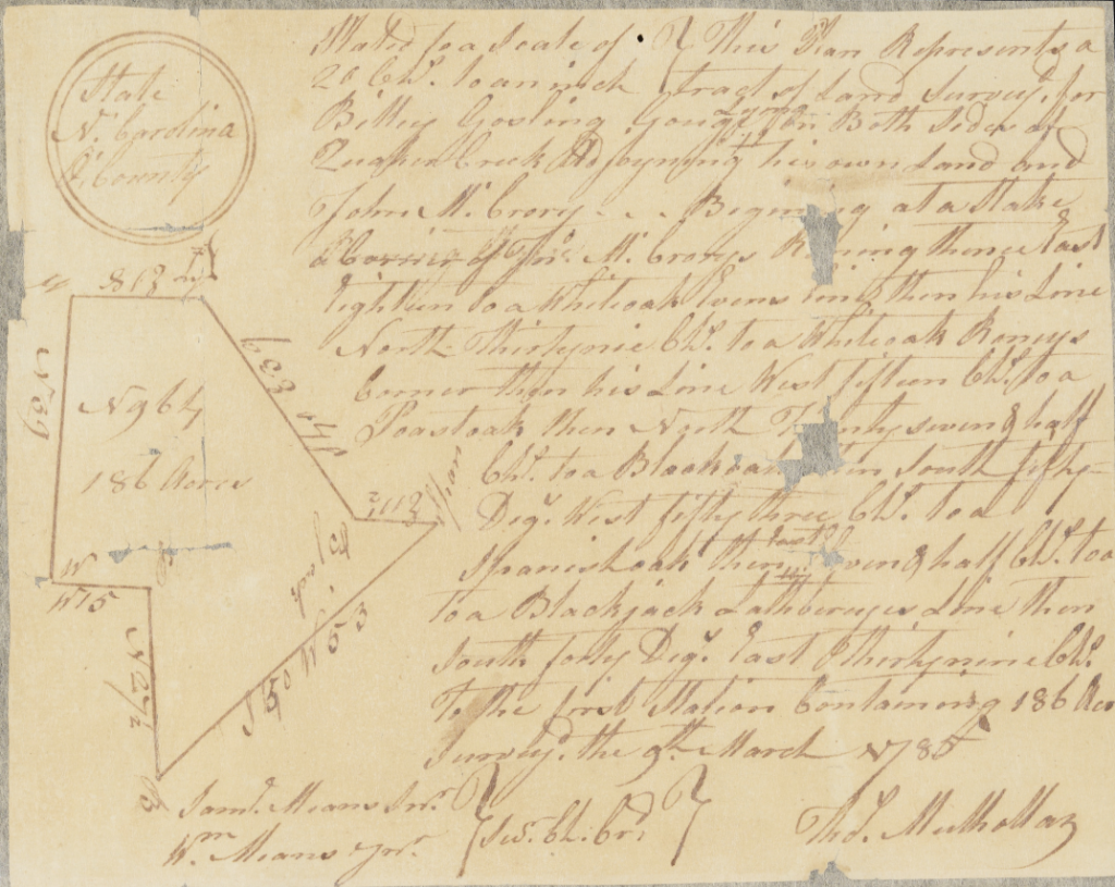
With the help of our partners at Graham Historical Musuem we are excited to announce the addition of new property records to DigitalNC. These materials include land grants, land surveys, property deeds and correspondences ranging from the late 18th century to the mid-19th century. Additionally, a military map from the 1960s and a photograph from 1923 are also included in this latest batch from Graham Historical Museum. The land grants, surveys, and property deeds are among some of the oldest records on DigitalNC and document land ownership in Orange County and present-day Alamance County. While most of these records are from Orange County, which was founded in 1752, Alamance County was formed in 1849 from parts of Orange County that may be represented in these Orange County land documents.
Understanding Land Surveys:
In the United States, most land east of the Ohio River (ie. North Carolina) that was surveyed in the 18th century was done so using the metes and bounds system. The systems primary unit of measurement was a chain, which was measured by standardized 66-foot chain. 1/4 of a chain was known as a pole and 1/100 of a chain was called a link. An acre was comprised of 10 square chains.
Since things like GPS technology and Apple Maps did not yet exist to conveniently tell one where they were located at any given time, land surveys of private property were usually not drawn in a manner that situated the property in relation to a broader mapped land area like a county. Instead this survey method used numerous markers (composed of both natural and man-made features) and the distances between them to measure the boundary of the property. What was ultimately produced as a result of these property surveys were hand-drawn shapes that represented a property’s spatial area. The context about where a piece of property was geographically located was given through a written explanation of the numerous monuments chosen as markers of the property’s boundary and the distances and directions between each of them.
Units of measurement in the metes and bounds system:
- Chain (sometimes abbreviated Ch.): 66 feet
- Pole: 16.5 feet or 1/4 of a chain
- Link: 7.92 inches or 1/100 of a chain
- Acre: 43,560 square feet or 10 square chains
- Direction: the direction one must travel to reach the next marker along the boundary line which is expressed by the degrees between cardinal directions
- Markers: natural or man-made features like trees, river banks, tributaries, existing properties, or roads that serve as visual markers of a property’s boundary
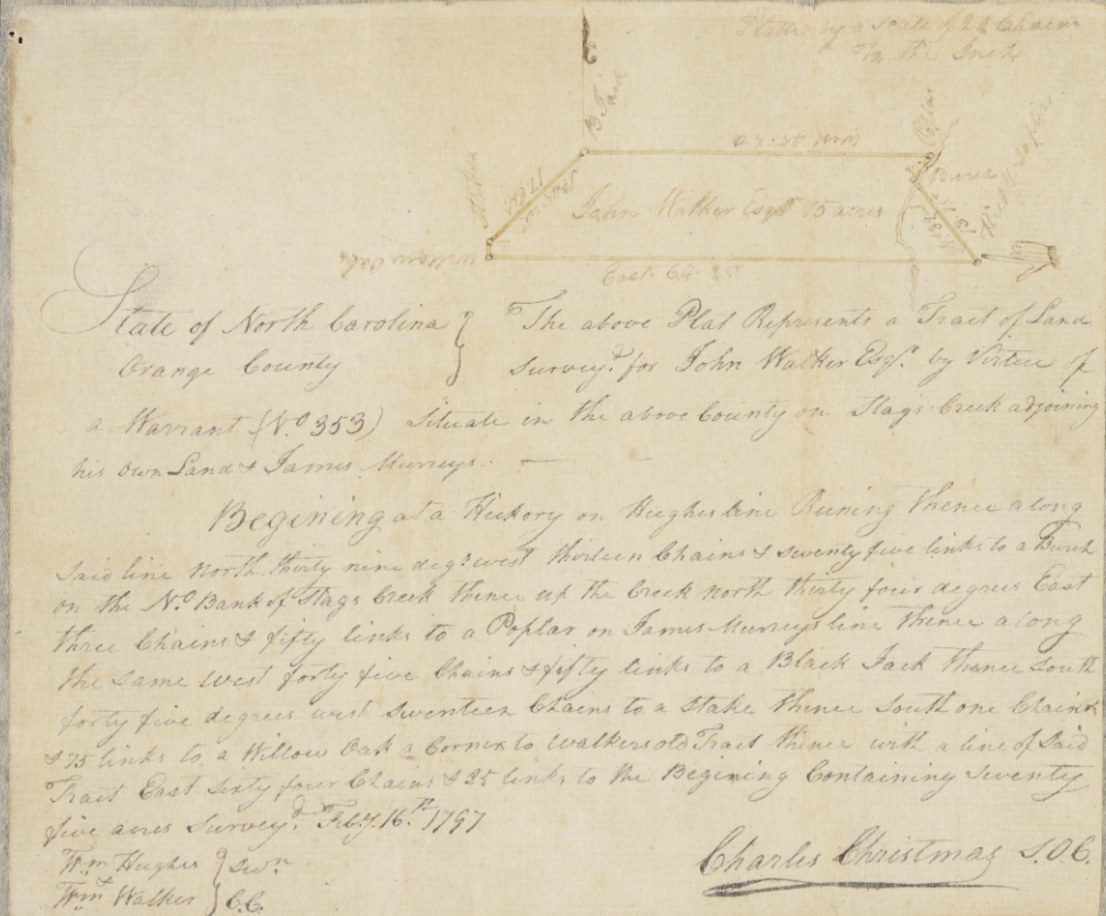
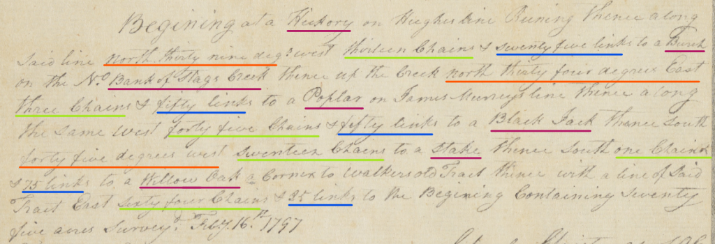
Featured below is an annotated close-up of the land survey from the Land Survey and North Carolina Land Grant (No. 1321) to John Walker, which is featured in full to the above right. This annotated version below is marked to show the different elements of a land survey like this one and how to read it. The survey begins with a marker (underlined in magenta) that serves as a starting point. In the survey below, a “hickory” on the Hughes property line is chosen as the starting spot. From here the direction to the next marker is denoted by the degrees between two cardinal directions (underlined in orange). In this instance, the survey says to go “north thirty nine deg. west.” Following the directions & degree is the length of distance that one must go to reach the next marker, which is denoted by chains (underlined in green) and sometimes smaller units like links (underlined in blue). In this survey one must travel “thirteen chains” and “twenty five links”, which together is about 1,056 feet, to the next marker which is identified as a “Birch on the N[orth] Bank of Stags Creek”. With the description of this next marker, the process begins all over again and the marker + direction + distance formula continues until the boundary formed by these markers finally leads back to the beginning marker. The total area confined by this boundary, as expressed by acres, commonly concludes the written land survey.
More information about our partner, Graham Historical Museum, can be found on their website here.
More materials including yearbooks, scrapbooks, and maps, can be found on Graham Historical Museum’s contributor page, which is linked here.