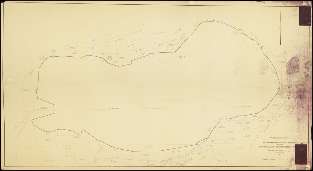
While we are no strangers to digitizing large objects here at DigitalNC, our newest partner, the Hyde County Historical and Genealogical Society, gave us quite the scanning challenge with their 1934 Mattamuskeet Lake Migratory Bird Refuge Grant Map! Measuring in at 6ft 4in by 3ft 9in, the map was over a foot longer than our largest scanning table. Since it was impossible for us to scan the whole map in one shot, we had to utilize our Phase One camera and its removable table top to scan the map in parts using a horizontal scrolling type technique.
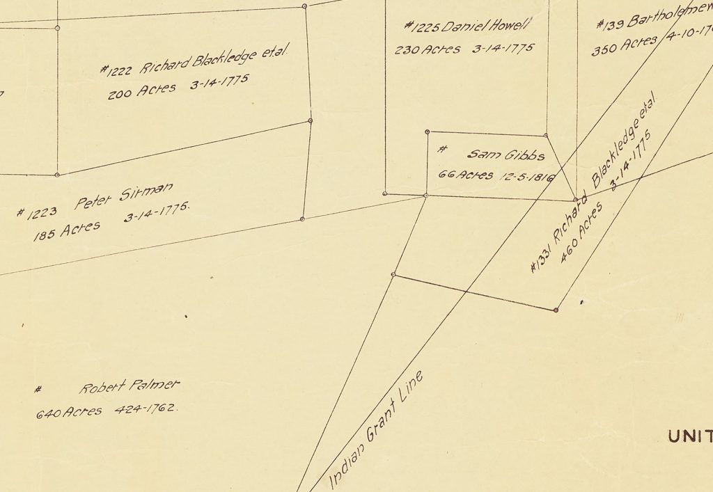
A portion of the map was set up on the table top with small weights carefully applied to hold the map in place and edges down while library carts and people supported the parts of the map off the table. Once a portion was scanned, the weights would be removed, the map shifted for the next portion (with overlap), and weights reapplied. This process was repeated over 30 times. Afterwards, the scanned images were pieced together to create an impressive full digital image of the map which shows the boundary of the lake and parcels of land along with individual parcel owner names, dates the land was acquired, and parcel acreage. A more detailed version of the map can be viewed here on DigitalNC.
Lake Mattamuskeet is recognized as North Carolina’s largest natural freshwater lake—stretching 18 miles long, seven miles wide, and averaging only two to three feet deep. While the lake may be shallow, its history is certainly not. The following paragraphs provide some information about the lake’s ancient and more recent past, but detailing its full history is beyond the scope of this blog post. If you are interested in learning more, please visit the resources that are linked at the end of this post.
At least 800 years before England’s 1584 expedition arrived at Roanoke Island, the coastal region of the state was occupied by several small Native American tribes, including the Algonquian-speaking Machapunga (also known as the Mattamuskeet or Marimiskeet American Indians). The Machapunga were a small tribe of the Algonquin language living in the Pungo River area who migrated south from the Algonquin peoples of the Powhatan Confederacy.
At that time, the Mattamuskeet were known as skillful watermen who made their boats and nets of size interlocks for herring, drum, shad, netting needles, and floats. In addition to their work on the water, they hunted; trapped; gathered berries, nuts, and fruit; and farmed. They grew plants such as corn, beans, pumpkins, goosefoot, sunflowers, knotweed, and squash. The women of the Machapunga are specifically noted as being fierce warriors. Today, the genealogical descendants from the original historic Mattamuskeet Indians of Hyde County, along with the original historic Roanoke-Hatteras (Croatan) Indians of Dare County comprise the Alogonquian Indians of North Carolina.
In 1934, the Mattamuskeet Lake Migratory Bird Refuge Grant Map was created—showing parcel boundaries along with providing the name of the parcel’s owner, the acreage, and the date it was acquired. Some names present on the map, such as Collins, Barber, Chance, Clayton, and Bryant, can trace their American Indian heritage back to the Mattamuskeet. The same year the map was published, the lake was acquired by the United States Government and the Mattamuskeet National Wildlife Refuge was established. This was likely a result of Roosevelt’s New Deal policies that helped provide jobs and relief to citizens during the Great Depression. Today, the Mattamuskeet National Wildlife Refuge (which includes the lake and surrounding area) remains federally protected and supports “large numbers of wintering waterfowl, as well as a variety of breeding songbirds, mammals such as black bear and bobcat, and other wildlife.”
![Map title and associated information. United States Department of Agriculture Bureau of Biologial Survey. Jay. N. Darling. Chief.
Mattamuskeet Lake Migratory Bird Refuge Grant Map.
New Holland Corporation Tr[?].
(3)
Hyde County. North Carolina.
R.C.F. Surveyor.
1934.
Scale 1:15,840
[Bar for scale]](https://www.digitalnc.org/wp-content/uploads/2023/11/default-1-1-1024x623.jpg)
To learn more about the Hyde County Historical and Genealogical Society, please visit their website linked here.
To view more maps of North Carolina on DigitalNC, click the following link.
History and information about Lake Mattamuskeet was found using the Lake Mattamuskeet and Mattamuskeet Indians NCpedia entries.
Information about the Algonquian Indians of North Carolina was found on their website linked here and the National Park Service’s page “The Carolina Algonquian.”